Difference between revisions of "Submissions:2018/OpenStreetMap mapping party!"
(update) |
(format) |
||
| Line 36: | Line 36: | ||
'''UPDATE''': The area around OSU is very well mapped, so we will instead focus on mapping for Humanitarian OpenStreetMap Team (HOT) and disaster mapping. |
'''UPDATE''': The area around OSU is very well mapped, so we will instead focus on mapping for Humanitarian OpenStreetMap Team (HOT) and disaster mapping. |
||
| − | === |
+ | === Humanitarian mapping === |
| + | |||
| + | ==== Getting started ==== |
||
* https://www.openstreetmap.org/user/new |
* https://www.openstreetmap.org/user/new |
||
| Line 44: | Line 46: | ||
* http://mapgive.state.gov/learn-to-map/ |
* http://mapgive.state.gov/learn-to-map/ |
||
| − | === Tasks === |
+ | ==== Tasks ==== |
* https://tasks.hotosm.org/project/5126 |
* https://tasks.hotosm.org/project/5126 |
||
| Line 50: | Line 52: | ||
* https://tasks.openstreetmap.us/ |
* https://tasks.openstreetmap.us/ |
||
| − | === Contact / get involved === |
+ | ==== Contact / get involved ==== |
* https://www.hotosm.org/ |
* https://www.hotosm.org/ |
||
| Line 61: | Line 63: | ||
| + | === Original proposal === |
||
| − | |||
| − | --- |
||
This workshop will be hands-on opportunity to get an introduction to the OpenStreetMap project, go outside in the local area to collect some map data, and then enter it into OpenStreetMap. |
This workshop will be hands-on opportunity to get an introduction to the OpenStreetMap project, go outside in the local area to collect some map data, and then enter it into OpenStreetMap. |
||
Revision as of 17:17, 20 October 2018
This submission has been accepted for WikiConference North America 2018.
- Title
OpenStreetMap mapping party
- Theme (optional)
tech & tools or other (technical experience not really requied)
no
- Author
Katie Filbert
- E-mail address
- Wikimedia username
aude
- Affiliation(s) (optional)
WM-NYC
- Abstract
UPDATE: The area around OSU is very well mapped, so we will instead focus on mapping for Humanitarian OpenStreetMap Team (HOT) and disaster mapping.
Humanitarian mapping
Getting started
Tasks
Contact / get involved
- mailing list: https://lists.openstreetmap.org/listinfo/hot
- @hotosm on Twitter
Original proposal
This workshop will be hands-on opportunity to get an introduction to the OpenStreetMap project, go outside in the local area to collect some map data, and then enter it into OpenStreetMap.
Two consecutive open space slots are requested for this workshop, as it has two components:
- Part 1
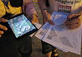
We will begin with a quick introduction to OpenStreetMap, including what the project is about, how to edit and how to collect data. You will learn about field papers, which are printed maps that we can take notes on, and mobile apps available that we can use while out mapping in the field.
We will then divide the target mapping area into smaller portions, organize participants into small groups, and assign groups to the areas. Participants will get field papers and if they wish, may also use their mobile devices (not required, though).
There likely is an abundance of areas around the venue that we can choose as our focus mapping area. Also, where the map does have data, it can quickly become outdated (especially shops and restaurants) and it is necessary to regularly update the map. We will choose an appropriate area near the venue to map.
We will allocate about an 30-35 minutes for the groups to go outside to collect map data.
- Part 2
Then we will reconvene at the venue and together we will enter the data into OpenStreetMap. To enter the data, you can use either the new iD editor which is the more simple editor on openstreetmap.org or if you want to learn more advanced editing (well, it's not that difficult!), then we can show you how to edit and enter the data using JOSM.
- About the presenter
aude is an "addicted mapper", contributing to OSM since 2008. [1] She also is a member of the Humanitarian OpenStreetMap Team, helping with response to the 2010 Haiti earthquake.
Beyond OpenStreetMap, she has contributed to Wikimedia projects for over 10 years and worked a software engineer on the Wikidata project for WMDE.

Mapping the National Zoo in Washington, DC (2009)

OSM mapping party in Haifa, at Wikimania 2011

OSM mapping party, Wikimania 2012 at Congressional Cemetery
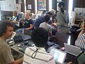
OSM mapping party and workshop in Kamaishi, Japan (September 2012)

OSM workshop at Wikimania 2013
OSM mapping party at Wikimania 2013


- Length of presentation/talk (see Presentation Types for lengths of different presentation types)
- Length of presentation
at least 75 min, ideally enough time to go outside, walk around and collect some data and then enter it into OpenStreetMap
- Special requests
- Preferred room size
- Have you presented on this topic previously? If yes, where/when?
Aude has co-presented an OSM workshop and organized a mapping party at Wikimania 2011, Wikimania 2012, Wikimania 2013, and at Wiki Conference NYC 2010, Wiki Conference USA/North America 2014, along with numerous local events with Mapping DC
- If you will be incorporating a slidedeck during your presentation, do you agree to upload it to Commons before your session, with a CC-BY-SA 4.0 license, including suitable attribution in the slidedeck for any images used?
- Will you attend WikiConference North America if your submission is not accepted?
likely
Interested attendees
If you are interested in attending this session, please sign with your username below. This will help reviewers to decide which sessions are of high interest. Sign with four tildes. (~~~~).
- Interested in helping out. Minh Nguyễn 💬 07:01, 23 August 2018 (UTC)
- Add your username here.